


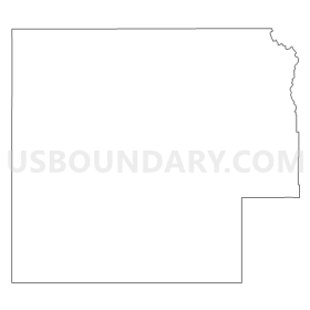
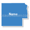
Northwest Colorado--Garfield, Routt, Moffat & Rio Blanco Counties PUMA, Colorado
About
Outline
Summary
| Unique Area Identifier | 192462 |
| Name | Northwest Colorado--Garfield, Routt, Moffat & Rio Blanco Counties PUMA |
| State | Colorado |
| Area (square miles) | 13,297.70 |
| Land Area (square miles) | 13,273.81 |
| Water Area (square miles) | 23.89 |
| % of Land Area | 99.82 |
| % of Water Area | 0.18 |
| Latitude of the Internal Point | 40.21032110 |
| Longtitude of the Internal Point | -107.92770370 |
Maps


Graphs
Select a template below for downloading or customizing gragh for Northwest Colorado--Garfield, Routt, Moffat & Rio Blanco Counties PUMA, Colorado


Neighbors
Neighoring Public Use Microdata Area (by Name) Neighboring Public Use Microdata Area on the Map
- Eagle, Summit, Grand & Jackson Counties PUMA, CO
- Mesa (Outside Grand Junction City), Montrose, Delta, San Miguel & Ouray Counties PUMA, CO
- Natrona, Carbon & Converse Counties PUMA, WY
- Southeast Utah & Uintah Basin Region PUMA, UT
- Sweetwater, Fremont, Uinta, Sublette & Hot Springs Counties--Wind River Reservation PUMA, WY
Top 10 Neighboring County (by Population) Neighboring County on the Map
- Mesa County, CO (146,723)
- Garfield County, CO (56,389)
- Eagle County, CO (52,197)
- Sweetwater County, WY (43,806)
- Uintah County, UT (32,588)
- Routt County, CO (23,509)
- Pitkin County, CO (17,148)
- Carbon County, WY (15,885)
- Grand County, CO (14,843)
- Moffat County, CO (13,795)
Top 10 Neighboring County Subdivision (by Population) Neighboring County Subdivision on the Map
- Vernal CCD, Uintah County, UT (26,835)
- Glenwood Springs CCD, Garfield County, CO (25,274)
- Fruita CCD, Mesa County, CO (23,655)
- Eagle-Gypsum CCD, Eagle County, CO (18,567)
- Steamboat Springs CCD, Routt County, CO (16,818)
- Rifle CCD, Garfield County, CO (13,236)
- Craig CCD, Moffat County, CO (13,002)
- New Castle CCD, Garfield County, CO (11,838)
- Rawlins CCD, Carbon County, WY (11,065)
- Basalt CCD, Eagle County, CO (8,251)
Top 10 Neighboring Place (by Population) Neighboring Place on the Map
- Steamboat Springs city, CO (12,088)
- Glenwood Springs city, CO (9,614)
- Craig city, CO (9,464)
- Rifle city, CO (9,172)
- Carbondale town, CO (6,427)
- New Castle town, CO (4,518)
- Battlement Mesa CDP, CO (4,471)
- El Jebel CDP, CO (3,801)
- Silt town, CO (2,930)
- Meeker town, CO (2,475)
Top 10 Neighboring Unified School District (by Population) Neighboring Unified School District on the Map
- Mesa County Valley School District 51, CO (143,321)
- Eagle County School District RE 50, CO (44,055)
- Roaring Fork School District RE-1, CO (37,655)
- Uintah School District, UT (32,588)
- Sweetwater County School District 1, WY (30,043)
- Garfield School District RE-2, CO (25,009)
- Steamboat Springs School District RE-2, CO (17,453)
- Moffat County School District RE-1, CO (13,795)
- Sweetwater County School District 2, WY (13,657)
- Carbon County School District 1, WY (11,195)
Top 10 Neighboring State Legislative District Lower Chamber (by Population) Neighboring State Legislative District Lower Chamber on the Map
- State House District 54, CO (86,291)
- State House District 61, CO (79,637)
- State House District 55, CO (79,305)
- State House District 56, CO (79,238)
- State House District 57, CO (78,537)
- State House District 55, UT (38,435)
- State House District 53, UT (37,757)
- State House District 17, WY (9,400)
- State House District 47, WY (7,767)
Top 10 Neighboring State Legislative District Upper Chamber (by Population) Neighboring State Legislative District Upper Chamber on the Map
- State Senate District 7, CO (152,044)
- State Senate District 8, CO (148,629)
- State Senate District 16, CO (136,132)
- State Senate District 5, CO (128,103)
- State Senate District 26, UT (101,392)
- State Senate District 27, UT (93,972)
- State Senate District 12, WY (17,585)
- State Senate District 11, WY (16,180)
Top 10 Neighboring 111th Congressional District (by Population) Neighboring 111th Congressional District on the Map
- Congressional District 2, UT (890,993)
- Congressional District 2, CO (733,805)
- Congressional District 3, CO (706,186)
- Congressional District (at Large), WY (563,626)
Top 10 Neighboring Census Tract (by Population) Neighboring Census Tract on the Map
- Census Tract 9520.02, Garfield County, CO (8,075)
- Census Tract 1, Pitkin County, CO (7,681)
- Census Tract 9682, Uintah County, UT (7,450)
- Census Tract 15.02, Mesa County, CO (7,214)
- Census Tract 9519.02, Garfield County, CO (7,097)
- Census Tract 9521, Garfield County, CO (6,041)
- Census Tract 9518.03, Garfield County, CO (5,934)
- Census Tract 3.01, Eagle County, CO (5,800)
- Census Tract 9402.01, Uintah County, UT (5,753)
- Census Tract 9520.01, Garfield County, CO (5,161)
Top 10 Neighboring 5-Digit ZIP Code Tabulation Area (by Population) Neighboring 5-Digit ZIP Code Tabulation Area on the Map
- 82901, WY (27,971)
- 84078, UT (25,851)
- 80487, CO (16,745)
- 81601, CO (15,442)
- 81623, CO (15,235)
- 81650, CO (13,006)
- 81625, CO (12,921)
- 81637, CO (7,721)
- 81647, CO (7,104)
- 81635, CO (5,957)